Cruising on Last Dance


This blog archives the adventures of Glen and Jill Moore and provides a means of communication for friends and family. Exploration and adventure have been synonymous with boats and water for centuries. The joy of adventures shared while exploring new places and meeting new people has built a strong bond for Glen and Jill. Last Dance is the platform for the exploration.

"The world is a book, and those who do not travel read only a page." St. Augustine, 354 - 430

“Twenty years from now you will be more disappointed by the things that you didn't do than by the ones you did do. So throw off the bowlines. Sail away from the safe harbor. Catch the trade winds in your sails. Explore. Dream. Discover.” Mark Twain, 1835 - 1910

"There is nothing -- absolutely nothing -- half so much worth doing as simply messing around in boats." The Wind in the Willows, 1908, Kenneth Grahame, 1859 - 1932

"I've never believed speed and ease are conductive to living fully, becoming aware, or deepening memory, a tripod of urges to stabilize and lend meaning to life." River Horse: a log book of a boat across America, 1999, William Least Heat-Moon,1939 -

The Great Loop -- The current adventure is a circumnavigation of the Eastern United States, cruising north up the east coast through New York into Canada, across the Great Lakes to Chicago, navigating multiple river systems south to Mobile, along the Gulf coast to the Florida Keys and back to St. Augustine. This trip by boat is commonly referred to as the Great Loop. Progress and current location are indicated by the red line on the map to the right. It was titled the Traceless Path in recognition of a German sailor we met in St. Augustine who published booklets of his travels with hand-drawn, detailed maps describing his travels across the water as the Traceless Path.


Wednesday, March 9, 2011

Navigation

Navigation of a boat is quite a bit more challenging than following a road cross country.  I have tried to think of an analogy for our land-bound friends (LBFs) with little success.  Let's try picturing a plain in Kansas, perfectly flat, a foot of snow has covered everything perfectly smooth, there are no road signs, fence posts, just white snow.  Think you could find the roadway?  This analogy does have a flaw in that the roadway is the same place it was before.  On the water, the deep water (roadway) keeps changing, it does not stay in the same place as does a paved road.  Oh, our LBFs will say, you have a GPS and chartplotter to tell you where you are and where you should be going; we saw it in your first post.  Remember the remark about the water-based roadways moving.  To make sure you can find the deep water you must check charts, guides, various web sites, ask for local knowledge, and learn to read the water.  Navigation challenges are one of the things that makes cruising on the water intellectually interesting and keeps you alert.


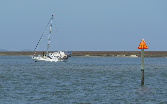
The photo above was taken in Georgia on the Cumberland River, March 2nd.  These sailors are not having a good day.  The spot where their boat lies aground is marked as deep water on the paper charts and the chartplotter.

1 comment:

Darrell and Linda said...

Hi Dr. Moore and Jill,

I bet you're having a wonderful time. Well you're definitely underway. Congratulations for cutting the dock lines. Sorry I missed seeing you off. Your blog is wonderful. I can see by the water mark on channel marker the poor guy who ran aground will most likely not be there long. It looks like the water will rise. Remember, it is best to run aground at low water. Have fun.
Darrell